What happened in Guerrero
A magnitude 6.5 earthquake struck near San Marcos in the southern Mexican state of Guerrero at 7:58 a.m. local time on Friday, 2 January. The shaking reached Acapulco and Mexico City, roughly 290 kilometres from the epicentral area, setting off seismic alarms, sending residents into streets and briefly interrupting President Claudia Sheinbaum’s morning press conference.
By the end of the day, authorities had reported two deaths. Guerrero Governor Evelyn Salgado said a 50-year-old woman died when her home collapsed in a small community close to the epicentre. Mexico City Mayor Clara Brugada said a man died after an apparent medical emergency and a fall while evacuating a building. These were different kinds of casualties: one caused by structural collapse in the hardest-hit state, the other during an evacuation far from the epicentre.
The damage was similarly uneven. Associated Press reporting described landslides around Acapulco and on other Guerrero highways, as well as serious structural damage at a hospital in Chilpancingo that prompted patients to be moved. Reuters reported gas leaks and damage to homes, public buildings, roads and hospitals around Guerrero. Mexico City and Acapulco airports recorded broken glass and other minor damage, but officials said operations continued.
That pattern is important. The earthquake was felt across a large part of southern and central Mexico, but feeling strong motion does not mean every place experienced the same damage. Distance from the rupture, local ground conditions and a building’s design all shape the result. The early reports point to concentrated physical damage in Guerrero, with more limited disruption in the capital.
Why the official measurements differ
Mexico’s National Seismological Service, or SSN, placed the earthquake near San Marcos at magnitude 6.5 and reported an initial depth of 5 kilometres. The U.S. Geological Survey also calculated magnitude 6.5 but placed the source 35 kilometres deep and slightly farther south. Those figures are not interchangeable: a shallow source can generally produce more intense local shaking than a deeper event of the same magnitude.
The difference does not mean one agency observed a separate earthquake. Seismological centres use different station networks, velocity models and calculation methods, and early parameters can change as more waveforms arrive. The SSN’s special report explicitly labels its information non-final and says it will refine the magnitude, epicentre and depth as additional data are received. For immediate public-safety reporting, the honest description is therefore a magnitude 6.5 event near San Marcos with materially different early depth estimates, not a falsely precise single location underground.
The SSN’s focal-mechanism analysis indicates reverse faulting associated with the convergence of the Cocos and North American tectonic plates. Along Mexico’s Pacific margin, the oceanic Cocos plate descends beneath the North American plate in a process called subduction. Guerrero consequently accounts for about a quarter of the earthquakes recorded in Mexico, according to the service.
This tectonic setting explains why earthquakes are recurrent; it does not make their timing predictable. The SSN cautioned that no scientific method can specify when and where a future earthquake will occur, how large it will be or what effects it will have. After a damaging event, claims that an individual aftershock or a larger earthquake can be forecast to a precise time should be treated with skepticism.
What the ShakeMap shows—and does not show
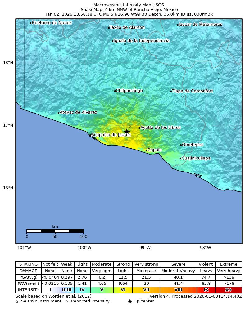
The USGS ShakeMap models the strongest motion along Guerrero’s Pacific coast, including the area around San Marcos, Ayutla de los Libres and Acapulco. It estimates shaking from instrumental observations and models; it is not a photograph, a casualty map or a building-by-building inspection. The yellow and orange areas indicate stronger estimated intensity, not proof that every structure inside them was damaged.
That distinction helps reconcile two features of the day’s reporting. Millions of people could feel the earthquake across several states while the most consequential structural reports clustered closer to the source. Conversely, a modest-looking regional damage total would not rule out severe loss for a household whose vulnerable building happened to fail.
Mexico’s seismic-warning system also performed a different job from the SSN. Warning networks detect an earthquake after it begins and can send alerts ahead of the most damaging waves to places farther away; they do not predict earthquakes. In Mexico City, the alarm gave people time to act before or as the shaking arrived. The death during evacuation is a reminder that an alert reduces some risks while creating an urgent need for calm, practised movement and safe evacuation routes.
Aftershocks and the next safety test
Aftershocks began immediately. The SSN counted 84 by 8:30 a.m.; by noon, Reuters reported 420, the largest then measured at magnitude 4.7. AP’s later account said the total had passed 500. These are time-stamped snapshots rather than contradictory final counts. More aftershocks can be expected as rocks around the rupture readjust, and the sequence may continue for days or weeks.
The immediate priority is inspection rather than prediction. Buildings that survived the main shock may have hidden damage, particularly masonry and adobe homes or facilities already showing cracks. Roads affected by landslides can also remain hazardous even after debris is moved. Residents should follow official civil-protection instructions and avoid entering visibly damaged structures until they have been assessed.
Several questions remained open on 3 January. Seismologists were still refining the earthquake’s location and depth. Damage teams had not completed a comprehensive survey of remote communities, roads and public buildings. The number and strength of aftershocks would continue to change. What was established was narrower: a magnitude 6.5 earthquake had killed two people, caused the most serious reported physical damage in Guerrero, and tested warning and response systems across a much wider region.