Reporting snapshot · 23 October 2026. Casualty and displacement figures are still being updated as rescue teams reach remote villages, and the death toll could rise. The figures come from Chinese officials, and no independent damage survey has been published.
A magnitude 7.0 earthquake struck Baqen county in Nagqu, northern Tibet, at 10:33pm local time on Thursday, killing at least 16 people and injuring 65, according to Chinese local-government updates cited by Reuters. More than 12,000 people have been moved to safer locations, Chinese state media reported, as rescuers worked through the night in a sparsely populated, high-altitude region.
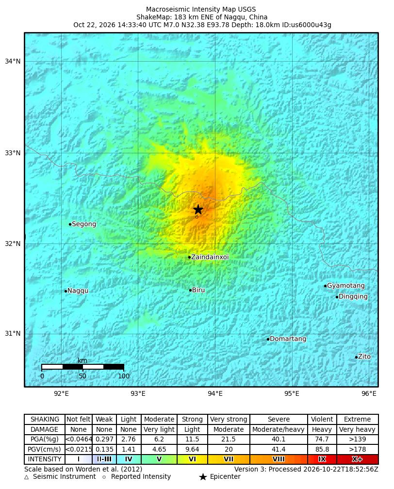
The United States Geological Survey recorded the quake at magnitude 7.0, with its epicentre about 191 kilometres east-northeast of Nagqu and 390 kilometres northeast of Lhasa. The agency put the depth at 18 kilometres. China’s earthquake network reported a shallower depth of 10 kilometres, a difference that affects estimates of how strongly the ground shook but not the scale of the emergency. The USGS event page classifies the event at orange alert level, meaning significant casualties and damage are possible.
What happened
The epicentre was in Maru township in Baqen county, a remote part of Nagqu city in the Tibet Autonomous Region, according to The News International, which cited Agence France-Presse and Xinhua. The area around the epicentre has an average elevation of about 4,864 metres, and the quake was felt strongly in the immediate area.
The Nagqu media office said at least 339 homes and 20 livestock sheds collapsed, Al Jazeera reported, citing city government officials. An earlier AFP tally cited by The News put the number of collapsed homes at more than 300. Electricity and telecommunications were disrupted in the county seat, and local fire and rescue teams were sent to the affected area.
By Friday, more than 300 traffic and community police officers had been sent to the epicentre to check damaged homes and help residents move, according to the Nagqu police department, as quoted by Reuters. State media said more than 12,000 people had been relocated. The China Earthquake Networks Centre recorded 413 aftershocks.
Why the casualty figures are still moving
The first reports after the quake put the number of injured at 32. Geo News said 11 of those people were in serious condition. Nikkei Asia, citing Reuters and Xinhua, also reported the 32 total late on Thursday. Al Jazeera later cited a local media office update of 46 injured, including 11 in serious condition. By Friday morning, the local government said 65 people had been injured, while the death toll remained at 16.
The sequence reflects updating counts, not necessarily a steady rise in the severity of the disaster: as rescuers reach more villages, they find and treat people who were not in the first tally. It also means the figures should be read as provisional. The report of 65 injuries on Friday did not include a full breakdown by severity, and earlier reports of 11 serious injuries may not capture everyone later admitted to hospital.
The death toll has stayed at 16 across the later updates. That does not establish that no one else has died. Officials have not said whether anyone remains unaccounted for, and no full building-damage assessment has been published. The 12,000-plus relocation figure is a count of people moved to safer locations, not a count of homes destroyed or of people who will need temporary housing through the winter.
Why this part of Tibet is vulnerable
The USGS says the quake resulted from normal faulting within the Tibetan Plateau, where the collision of the Indian and Eurasian plates raises the Himalayas and the plateau and produces widespread seismicity. The plateau is also spreading east-west under its own weight, and that extension is accommodated by normal and strike-slip faults. The USGS says normal-faulting earthquakes of this size typically occur on a fault plane of about 50 kilometres by 20 kilometres. The agency’s tectonic summary describes a fault dipping either northwest or southeast.
The region has a long record of destructive earthquakes. The USGS counts 29 earthquakes of magnitude 7.0 or larger on the Tibetan Plateau and its margins since 1900. A magnitude 6.9 quake in April 2010, about 272 kilometres east-northeast of this week’s epicentre, killed more than 2,500 people. The 1950 Assam-Tibet earthquake, magnitude 8.6, killed more than 4,000.
Sparsely populated terrain can limit the number of people exposed, but it also complicates rescue. Villages are scattered across high mountain valleys, roads are limited, and the cold at this altitude makes shelter urgent. The USGS estimates that about 111,000 people experienced moderate to severe shaking, a reminder that the impact of a large quake depends heavily on how close the rupture is to small settlements, not just on regional population density.
For Pakistan, the tectonic setting is a shared one. The same continental collision drives seismicity across the Himalayas and northern Pakistan, where earthquakes in the Hindu Kush and along the Himalayan front are felt far from their epicentres. A magnitude 5.5 quake in the Hindu Kush in April 2026 shook Islamabad, Peshawar and parts of Khyber Pakhtunkhwa, with no casualties reported. The Tibetan event is a reminder of how quickly a remote mountain earthquake can become a large-scale relief operation.
What is still uncertain
The most important unknown is the final death toll. The 16 figure has held through Friday morning, but rescuers were still working in damaged villages and the local government has not said whether all settlements have been reached. Aftershocks are another risk: the USGS warns that some could be strong enough to cause further damage, and the China Earthquake Networks Centre has recorded hundreds.
The condition of the injured is also unclear. Early reports singled out 11 people in serious condition; later totals did not say how many remain critical. The number of people left without shelter, and how long they will need it, has not been established. Nor is there a published account of damage to hospitals, schools, roads or communications beyond the initial reports of disruption in the county seat.
The Chinese government’s response is now focused on search and rescue, relocation and restoring services. How quickly those efforts reach the most remote valleys, and whether winter conditions close roads, will shape the next phase. The clearest confirmed facts are the magnitude, location and the rising injury count; the full human cost will take longer to establish.