Reporting snapshot · 8 October 2026 (Asia/Karachi). The World Meteorological Organization published its monthly Global Seasonal Climate Update on 8 October 2026. Its figures are seasonal forecasts assembled from an ensemble of models, not observations of the event's eventual peak, and the event can still evolve. Sources were reviewed on 8 October 2026.
What the WMO said
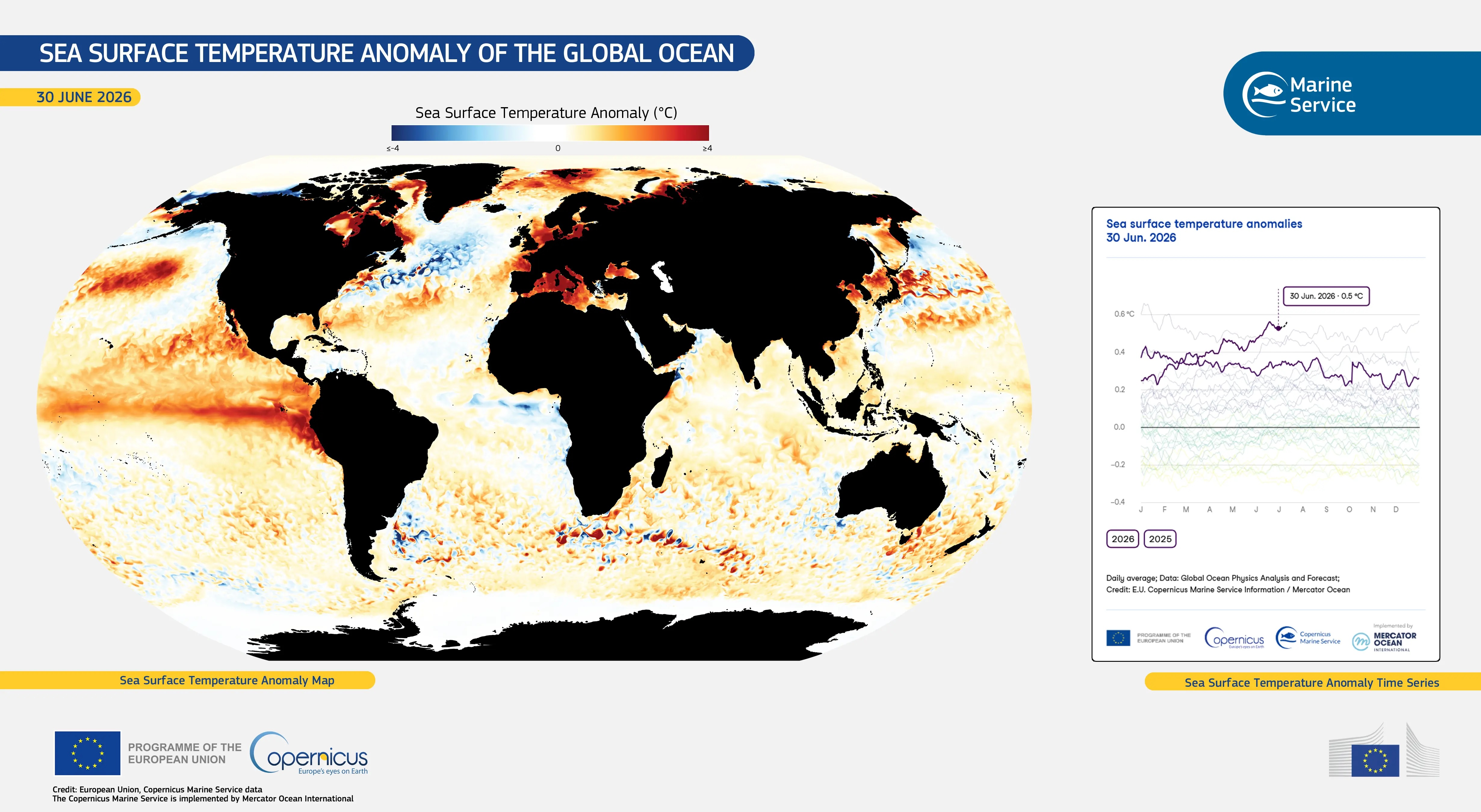
The World Meteorological Organization said on Thursday, 8 October that the El Niño that took hold in the tropical Pacific this year is strengthening rapidly and is forecast to push a key measure of sea-surface temperature to a record high this season.
In its monthly Global Seasonal Climate Update, the Geneva-based United Nations weather agency said the Niño 3.4 index — the sea-surface temperature anomaly across the central and eastern equatorial Pacific that scientists use to gauge El Niño — rose from about +1.6°C above normal in June 2026 to +2.5°C in August. For October–November–December, it is forecast to average about +3.7°C above normal, peaking around December. That would be the highest since observations began and would exceed the previous record of +2.6°C set in November 2015–January 2016.
“El Niño is firmly established and strengthening rapidly,” WMO Secretary-General Celeste Saulo said. The agency put the likelihood that the event persists through February 2027 at “near 100 per cent”, and said it could be “one of the strongest since at least 1950”.
The update’s headline numbers describe the ocean, not a weather outcome. The WMO said the strengthening event will “drive weather patterns and impact economies, ecosystems and communities across the globe”, and that it is likely to bring above-average temperatures to much of the world and shift rainfall patterns.
How the forecast is built, and how firm it is
The WMO’s seasonal update is a consensus product. Its El Niño reading draws on seasonal prediction systems run by thirteen national and international meteorological centres — from Washington to Tokyo, London and Pune — using ocean-buoy, satellite and radiosonde data coordinated by the agency.
El Niño is the warm phase of the El Niño–Southern Oscillation (ENSO), a natural cycle that recurs roughly every two to seven years and typically lasts nine to twelve months, alternating with its cool phase, La Niña. The WMO also weighs other ocean drivers in the same outlook. A positive Indian Ocean Dipole, which can strongly shape rainfall around the Indian Ocean, is expected to peak in October, with an October–December anomaly of about +0.5°C, while sea-surface temperatures in the equatorial Atlantic are forecast to remain above normal.
Those are forecast seasonal averages, not certainties. The WMO’s own chart of Niño 3.4 projections shows a spread among the contributing models, and the agency described the outlook as based on a consensus rather than a single forecast. The near-100 per cent figure describes how likely it is that El Niño conditions persist into early 2027; it is not a probability for any single weather outcome on the ground.
What it means for weather
A strong El Niño is likely to bring above-average temperatures to much of the globe and to shift rainfall patterns, “increasing the risk of drought and floods in different regions”, the WMO said.
According to the outlook, wetter-than-normal conditions are forecast for the Greater Horn of Africa, parts of Central and East Asia, northern parts of the Arabian Peninsula, parts of North America and south-eastern South America. Drier-than-normal conditions are expected across the Indian subcontinent, southern Central America, parts of the Caribbean and north-western South America.
Saulo stressed that El Niño does not add new heat to the planet but releases heat the ocean has already stored below the surface. “The ocean it’s drawing from is the warmest we’ve ever measured it. There is simply more heat available to release,” she said. The preceding El Niño helped make 2023 the second-hottest year on record and 2024 the hottest, at roughly 1.55°C above the 1850–1900 pre-industrial average, according to the account of the update carried by AFP.
Some regions are already feeling the effects. Central America’s dry corridor has seen crops and livestock lost to drought this year, AFP reported, an illustration of how an ocean signal in the Pacific translates into local hardship thousands of kilometres away.
Why it matters for Pakistan
For Pakistan, the most consequential line in the outlook is the forecast of drier-than-normal conditions across the Indian subcontinent. El Niño years are historically associated with below-normal monsoon rainfall over South Asia, and the Pakistan Meteorological Department attributed part of this year’s weak monsoon to developing El Niño conditions. National rainfall for July to September finished 19.3 per cent below normal, and the country entered its Rabi cropping season on 1 October with reservoir carryover at its lowest since 2021 and a projected water shortage of about 25 per cent.
A drier, hotter pattern raises the risk that the next monsoon is again suppressed and adds to heat and drought stress on agriculture and water supply. Pakistan’s National Drought Action Plan, approved earlier this year, is designed for exactly this kind of slow-onset risk, but its implementation is at an early stage.
The outcome will also depend on how the positive Indian Ocean Dipole and other regional drivers interact with El Niño; the two can reinforce or offset each other depending on timing. Seasonal forecasts for Pakistan’s next monsoon are still months away, and a global outlook cannot substitute for them.
What is still uncertain
The headline figure of +3.7°C is a seasonal average forecast, and the models behind it disagree at the margins. Whether this event ends up “among the strongest since 1950” will be settled by observations over the coming months, not by the October outlook. The timing of the December peak and the strength of its global effects can still change.
El Niño’s effects are also uneven and probabilistic. Not every El Niño produces the same rainfall outcome in a given place, and other climate drivers can offset or amplify it. The WMO says national meteorological services and regional climate forums are issuing their own updates to governments and humanitarian partners; for Pakistan, the Meteorological Department’s national seasonal forecasts, rather than a global average, will be the more useful guide as winter and spring approach.
Sources & reporting notes
This is a synthesis of published material, not eyewitness reporting. Sources were reviewed on 8 October 2026. The WMO's Global Seasonal Climate Update is the primary record for the forecast figures; the regional rainfall detail is taken from independent reporting of the same update. Forecasts quoted here are seasonal averages and probabilities, not observed outcomes or local forecasts.
- WMO — "Sea-surface temperatures reflect strengthening El Niño"8 October 2026 · Primary source: the Global Seasonal Climate Update, the Niño 3.4 figures for June, August and October–December, the December peak, the 2015-16 record, the near-100% persistence to February 2027, the thirteen-centre consensus, the Indian Ocean Dipole and Atlantic context, and Celeste Saulo's remarks.
- Geo News (AFP) — "El Nino will intensify, then peak in December: UN"8 October 2026 · Independent account of the update, the ENSO cycle, the 1.6°C–2.5°C progression, the +3.7°C forecast against the 2.6°C record, the 2023-24 temperature context and the Central America drought.
- The Express Tribune (Anadolu Agency) — "El Nino forecast to reach record strength as global heat, weather risks rise: WMO"8 October 2026 · The regional wetter- and drier-than-normal forecasts, the +3.7°C seasonal anomaly, the near-100% persistence figure and Saulo's "warmest we've ever measured it" remark.

.jpg)